Tropical Cyclone Alfred: Latest Forecast and Updates

Tropical Cyclone Alfred has made its presence known in the Coral Sea, drawing attention from meteorologists and Queensland residents alike. This storm began forming on February 23, 2025 and has rapidly intensified, bringing concerns about its impact on Australia’s eastern coast. As of late February 24, 2025, Alfred has reached category two status, and predictions indicate it could escalate to category three by the early hours of February 25. In this post, we’ll cover the latest developments on Alfred—its current status, projected path, and what it means for Queensland residents and visitors. Whether living in the region, planning a trip, or simply tracking the weather, keep reading for essential updates.
1. Tropical Cyclone Alfred: What We Know So Far
Every cyclone has its unique origin, and Alfred’s journey began in a low-pressure area over the warm waters of the Coral Sea. By February 23, 2025, it had intensified enough to be officially designated as a cyclone by the Bureau of Meteorology (BoM). Interestingly, the storm was initially set to be named “Anthony,” but authorities opted for “Alfred” to avoid confusion with Prime Minister Anthony Albanese—especially with an election approaching. Clear communication is key when dealing with natural disasters!
Since its formation, Alfred has gradually gathered strength. It originated approximately 840 kilometers east-northeast of Cairns and has been steadily growing in intensity. Currently classified as a category two cyclone on Australia’s five-tier scale, Alfred is already displaying considerable force—and it’s not showing signs of slowing down just yet.

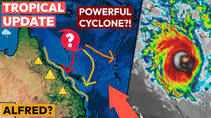
2. Tracking the Storm: Current Location and Strength
As of February 24, 2025, at 6:00 PM UTC (early morning February 25 for Queensland), Alfred is positioned at approximately 14.4°S 154.7°E in the Coral Sea. This location places it around 570 kilometers east-northeast of Willis Island and 970 kilometers northeast of Mackay, remaining well offshore from Queensland’s coastline. Moving at a pace of roughly 5 knots (9 km/h) toward the south-southeast, Alfred is making gradual progress.
In terms of strength, the cyclone is packing sustained winds of 60 knots (111 km/h), with gusts reaching up to 130 km/h. The central pressure is around 987 millibars, indicating its growing intensity. The storm’s influence extends far beyond its core, with gale-force winds (above 63 km/h) reaching up to 315 kilometers southeast and 148 kilometers northeast of the center.
Some meteorology enthusiasts on X (formerly Twitter) have suggested that Alfred’s winds may have already escalated to 75 knots (139 km/h), with a pressure drop to 975 mb, potentially pushing it into category three territory. However, until the BoM confirms these figures, it’s best to rely on official updates, as cyclone conditions can shift rapidly.
3. The Path Ahead: Where is Alfred Going?
Predicting a cyclone’s movement can be a challenge, as they often change course unexpectedly. At present, meteorologists anticipate Alfred will continue its south-southeast trajectory for the next couple of days, remaining in the Coral Sea and avoiding direct landfall on Queensland’s coast. Forecasts suggest it could intensify further, reaching category three status by February 25, 2025, which would bring severe conditions, including winds ranging from 118 to 157 km/h. Tropical Cyclone Alfred: Latest Forecast
Beyond February 27, forecasting models diverge on Alfred’s potential path. Some models, like the GFS, indicate the cyclone may continue drifting eastward over open waters, while others, such as the ECMWF, suggest it might turn westward and approach Queensland’s coastline. There’s also the possibility that Alfred could weaken if it encounters cooler waters or upper-level winds that disrupt its structure.
A significant high-pressure system to the south and east is currently influencing Alfred’s direction, but its future path remains uncertain. Until the situation becomes clearer, Queensland residents should stay alert for updates from the BoM and other weather authorities.
4. Preparing for Impact: What to Expect in Queensland
Even though Alfred remains offshore, its effects are already being felt along Queensland’s coast. Strong southeasterly winds have generated rough seas and large swells from Fraser Island to Townsville. Boaters and beachgoers are experiencing the impact, with some coastal events, such as a music festival on Great Keppel Island, being postponed due to the hazardous weather conditions.
Should Alfred shift toward the coast unexpectedly, the consequences could be severe. A Category Three cyclone has the potential to cause significant damage, including roof damage, uprooted trees, and power outages. Additionally, heavy rainfall could lead to flooding in low-lying areas, while storm surges might push seawater inland in vulnerable coastal regions. Cities such as Cairns, Townsville, Mackay, and Rockhampton would be particularly at risk.
For now, however, Alfred is expected to stay offshore, minimizing the immediate threat to land. Still, it’s wise to prepare in case conditions change. Residents should secure loose outdoor items, stock up on emergency supplies, and remain informed about weather updates. Those in flood-prone areas should take extra precautions, including moving valuable belongings to higher ground. Tropical Cyclone Alfred: Latest Forecast

5: How to Prepare – A Step-by-Step Safety Guide
Don’t wait until the last minute! Follow these steps to protect yourself and your family:
1. **Stay Informed:**
– Monitor updates from trusted sources like [local meteorological agency] or apps like [Windy, AccuWeather].
– Sign up for emergency alerts via SMS or community warning systems.
2. **Create an Emergency Kit:**4: How to Prepare – A Step-by-Step Safety Guide
– Pack non-perishable food, water (3–4 liters per person daily), medications, flashlights, batteries, and important documents in waterproof bags.
3. **Protect Your Home:**
– Trim tree branches near your house.
– Clear gutters and drains to prevent water buildup.
– Use sandbags to help divert floodwater from doors.
4. **Plan for Evacuation:**
– Know your nearest evacuation route and shelter.
– Keep your vehicle fueled and ready.
5. **During the Storm:**
– Stay indoors and away from windows.
– Listen to emergency broadcasts for real-time updates.
– Avoid flooded roads and downed power lines.